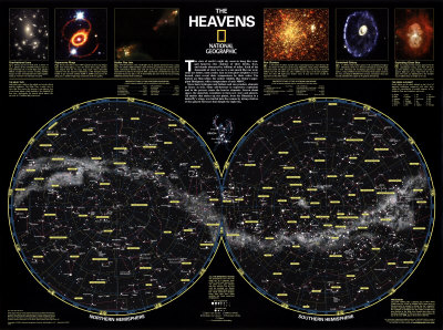
So your picture is looking at it from above or below???
Either, what it is is a depiction of the Milky Way Galaxy with no declination. If you look at the Galaxy as if it were a plate it would have some "thickness", the thickness is measured (relatiove to Earth) in terms of a declination angle answering the question is it above or below the plane formed by the equator in the sky. In my picture all the stars are "squished" into a thin sheet.
And my picture is looking at it from the side???
No, your picture is looking at it from inside. If you locate the sun in my picture, yours is what you see from there.
But, as I had asked earlier, regarding a "Common North" ---the Navigation chart shows a quite symetrical shap & an equal division the rising portion and the falling portion ---above & below the eqinox (northern hemisphere vs southern) like a sine wave shape.
The reason is how the co-ordinates are defined (look up declination), your chart is standard celestial chart defined as what you see in the sky from Earth. Mine is what you would see if you were outside the Milky Way Galaxy looking back at it (like we see the Andromeda Galaxy). The sine wave appearance is due to the fact that we are not in the Galactic Plane of the Milky Way, but a little above or below it.
That regular symetry equally divides a sine wave ---that you inform me is the Milkway seen sideways [or actually from inside looking outward].
Yep. Imagine holding a hula hoop at eye level so you are in the middle of the loop. Now tip it one way or another... the image is sinusoidal and symmetric.
The symetry lends itself to having a Top, sides and a bottom ---all along a reference base line.
Yep. "Top" on your map is the North Pole. On my map "Top" would be directly above the barred lens directly below the sun.
It would seem IMO that there are definitive cardinal points ---cardinal points that evenly divide the milkway's belt with percision. No?
From where we are, yes (as long as you do not consider the density of stars). The densest part of the Milky Way (what you see in the sky, what is on your map) is centered in the constellation Sagittarius (about 90 degrees along the bottom and 30 degrees south). The lightest is directly opposite (270 degrees by 30 degrees north). On my map (of the Milky Way Galaxy) zero degrees (going from sun directly downwards) is the same view (from way far away) as your map looking at 90 by 30 north) and my 180 degrees is equivalent to your 270 by 30.
The cardinal points splitting up the figure are a function of how astronomy maps things. If the Galactic Plane were made the reference, the Milky Way would be at zero degrees declination and "north" would not poinht to Polaris. Take up the huls hoop again, imagine you are under a street lamp (representing Polaris). Hold the hula hoop at eye level. This is what you would see if the Earth's equator was aligned with the galactic plane (it ain't). Now tilt up the part in your right hand by 30 degrees and tilt down the part in your left 30 degrees. This is the "offset" of the Earth's equator to the galactic plane, and you see your sinusoidal figure. Now tilt your head so the hula hoop is "level" for your eyes..... the streetlamp is no longer directly overheadm, right? That is what you would see if your map were made to be co-planar with mine.
This is bloody hard to expalin.


")
